Grasshopper’s North American 2024-2025 Snow Season Outlook, November Update - MountainWatch Travel
CALL NOW MESSENGER
JU7A6390_Insta

Grasshopper’s North American 2024-2025 Snow Season Outlook, November Update
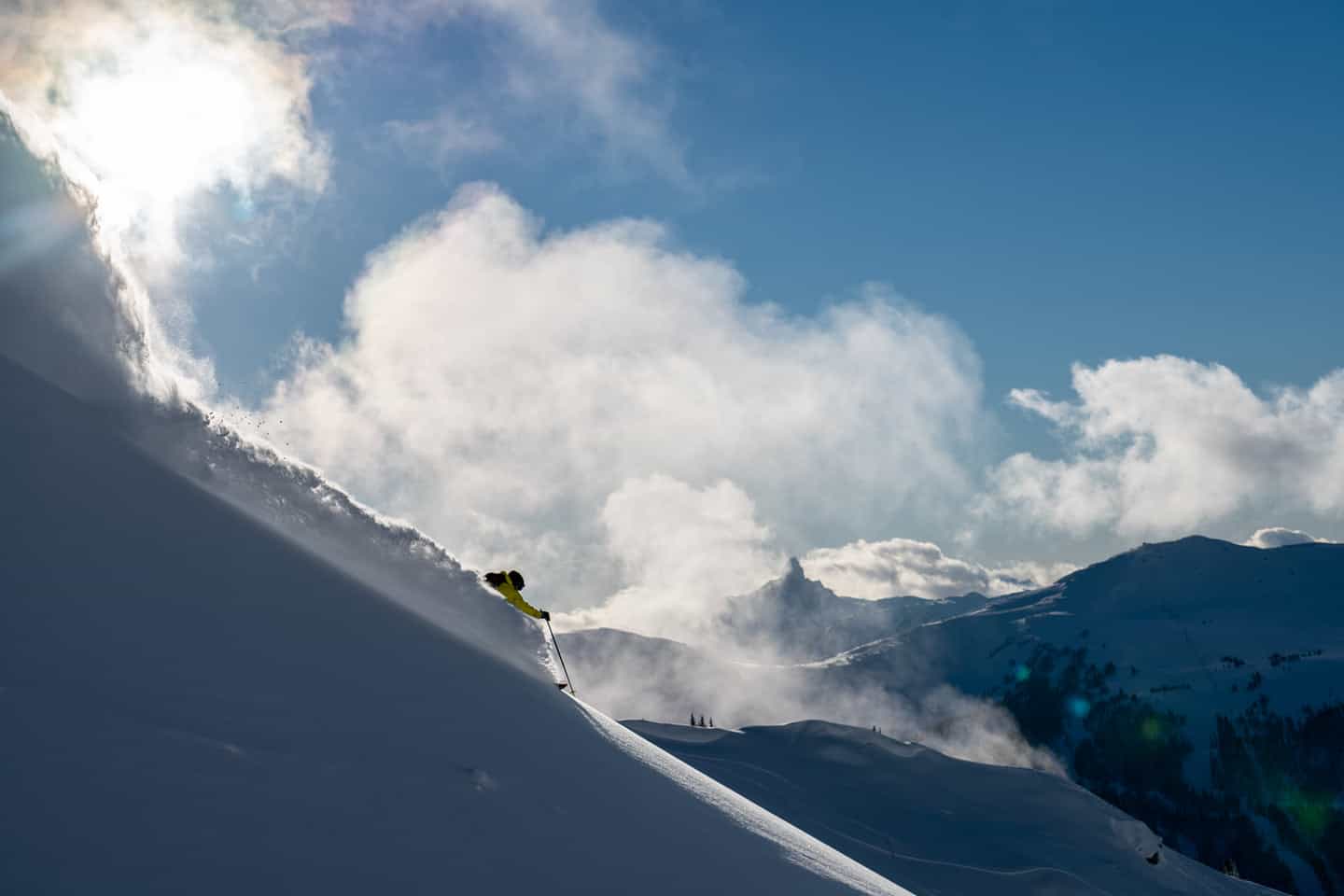
Even a weak La Nina is good news for resorts in British Columbia, with expected above average precipitation, below average temps and more days like this in Whistler Blackcomb. Photo Whistler/Blackcomb

Mountainwatch | The Grasshopper

After some good snowfalls in parts of the US and Canada over the past couple of weeks, quite a few resorts in North America already have lifts spinning and with likely heavy snowfalls on the way over the next week, winter is well and truly on the doorstep.

Starting today, a very strong storm in the Pacific will see the action over the next week focused on the Cascades in the Pacific Northwest, California’s Northern Sierras and the Coast Mountains in BC. An “atmospheric river” could result in some big snow totals, Whistler Blackcomb in line for 90+cms while Palisades Tahoe could see well over a metre of snow over the next 10 days.

Is this a sign of things to come? Maybe, as strong storms like this are not unusual in a La Niña or neutral year. Our last investigation into what we may expect this season hinted at the potential of a La Niña developing, so has much changed since my first North American season outlook? Let’s play spot the difference between that and updated conditions and discuss why things may be different.
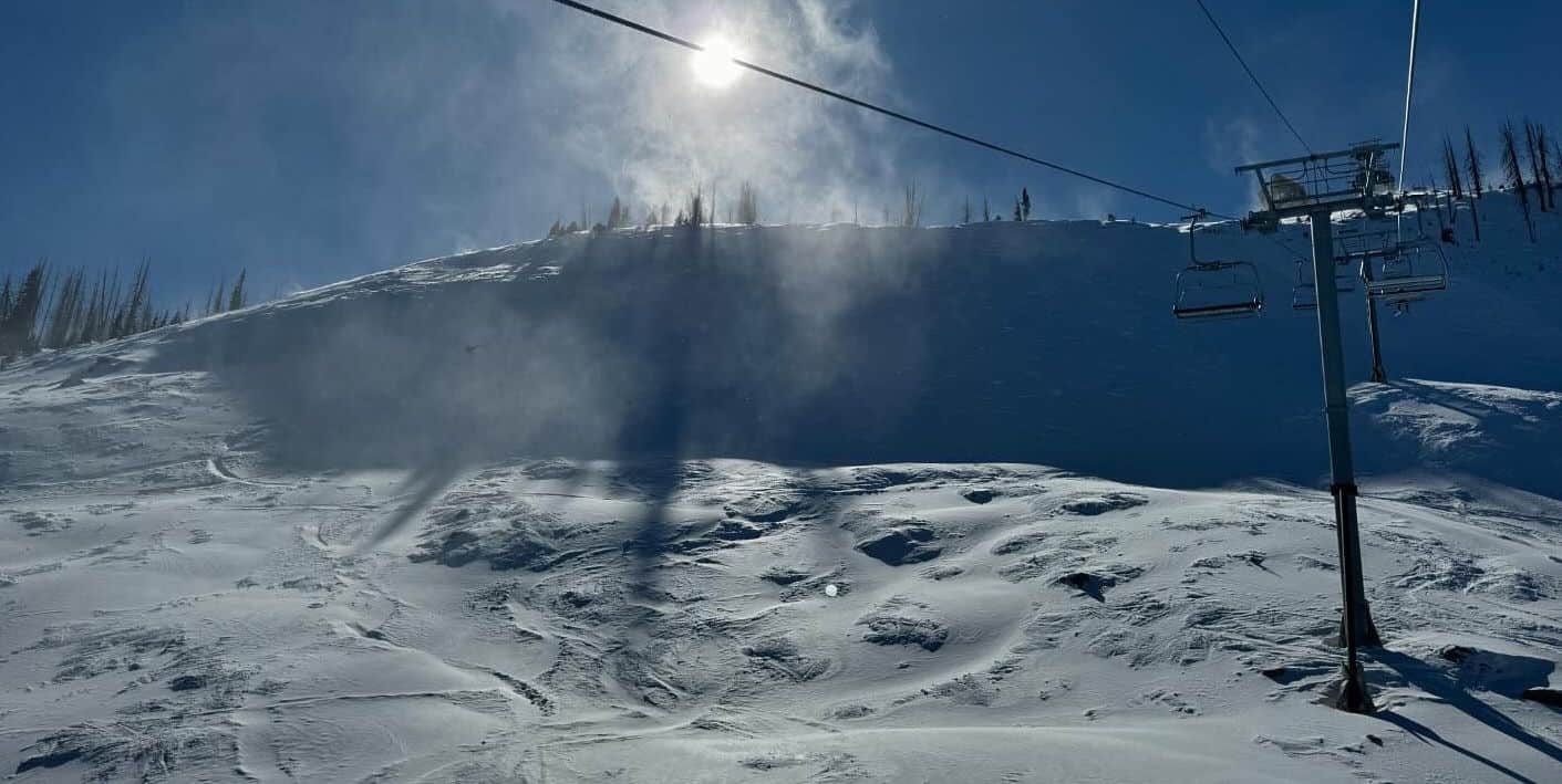
Wolf Creek, Colorado, today after 10cms overnight. It was one of the first resorts in North America to open for the season on October 22nd and is now 100% open. Photo: Wolf Creek Ski Area

ENSO

Last month the main story was the potential of a La Niña event developing over the coming winter. That potential is still likely, NOAA (National Oceanic and Atmospheric Administration) currently putting the chance of an event occurring at 57%, slightly down from the 60% chance we saw a month ago. Also, as discussed last month, if we do see a La Niña event reached this winter it is most likely to be weak, so its usual impacts can be dampened.

Below is a comparison of the global SST anomalies from October 13th on the left and of November 17th on the right. Overall, there is not a major difference between the two ­– we still have a pattern that looks like a La Niña is trying to emerge, but there isn’t any significant development. Waters around the west Pacific are very similar and there’s a slightly increased extent of cooler waters in the central-eastern regions. ENSO events do typically reach their maximum during the Dec-Feb period, so we can still expect this pattern to develop into winter.
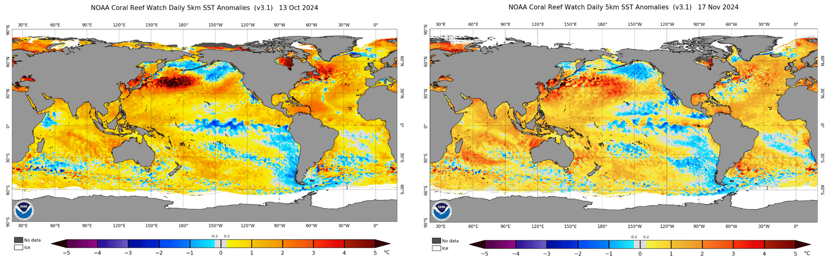
A comparison of the global daily sea surface temperature (SST) anomaly from the 13th of October (left) and the 17th of November (right). Quite a similar picture with hints of a La Nina event trying to emerge. Source: NOAA

NOAA Comparison

Before we look at the comparison between this and last months’ seasonal outlooks from NOAA and Environment Canada, I’ll quickly revisit why the pattern looks the way it does.

Below is a comparison between the forecasted MSLP anomaly over the coming winter. We see an area of high pressure in the Northern Pacific and an area of low pressure in northeastern Canada, which are typically present for a La Niña event. The annotated forecast on the right shows an idealised path of the Polar Jet in a La Niña like set up, with the high pressure at the surface often reaching high up into the atmosphere. This brings cold air from the north and moisture from the Pacific in the form of storms directing it over northwestern USA/southwestern Canada.
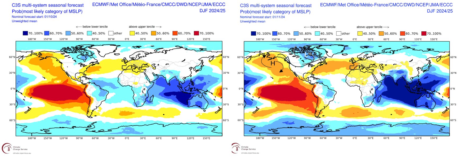
Forecasted Mean Sea Level Pressure (MSLP) anomalies for the upcoming winter season from last month (left) to this month (right). The right map features annotations showing an idealised path of the Polar Jet in black between a blocking high and low pressure circulation for a La Nina like pattern. Source: Copernicus Climate Change Service (vandalised by the Grasshopper).

Moving to the more specific products, the image below compares NOAA’s seasonal temperature outlook from last month to this month. Spatially the pattern is very similar, the largest difference to note is the increase in area of below-average temperatures in the northwest. We can see that pattern outlined earlier and considering the likelihood of a La Niña event being weak in the Pacific, it is interesting to note the increase in the extent of forecasted below-average temperatures. That illustrates that weak events can still have impacts on seasonal temperatures and snowfall.
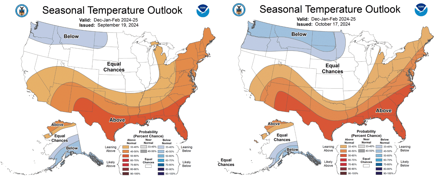
A comparison between the seasonal temperature outlooks for the coming winter from last month (left) and this month (right). Subtle differences between the two. Source: NOAA

Speaking of snowfall, the comparison map below shows the NOAA forecasted precipitation outlook for the winter, the left issued on September 19th, the tight on October 17th. Again, the pattern is very similar except for the updated version we see reduction in the extent of above average precipitation across the north. Again, the northwest is best positioned for the upcoming season.
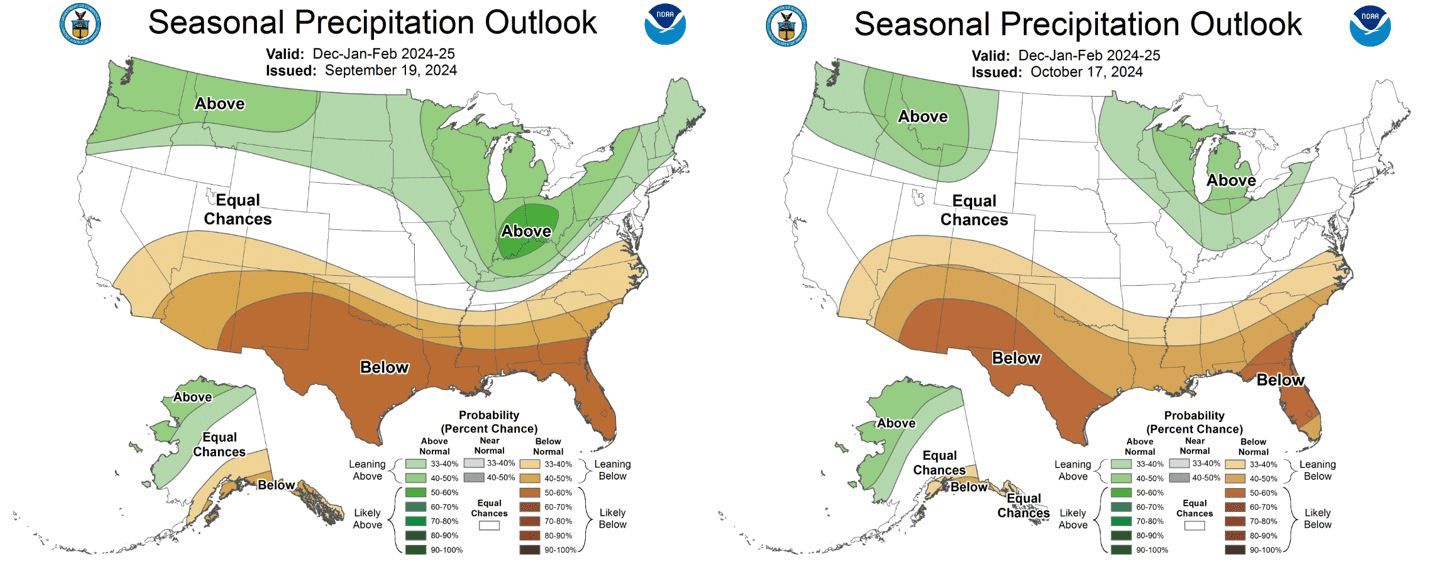
A comparison between the seasonal precipitation outlooks for the coming winter from last month (left) and this month (right). Once again subtle differences in the north and south with the main pattern looking quite similar. Source: NOAA

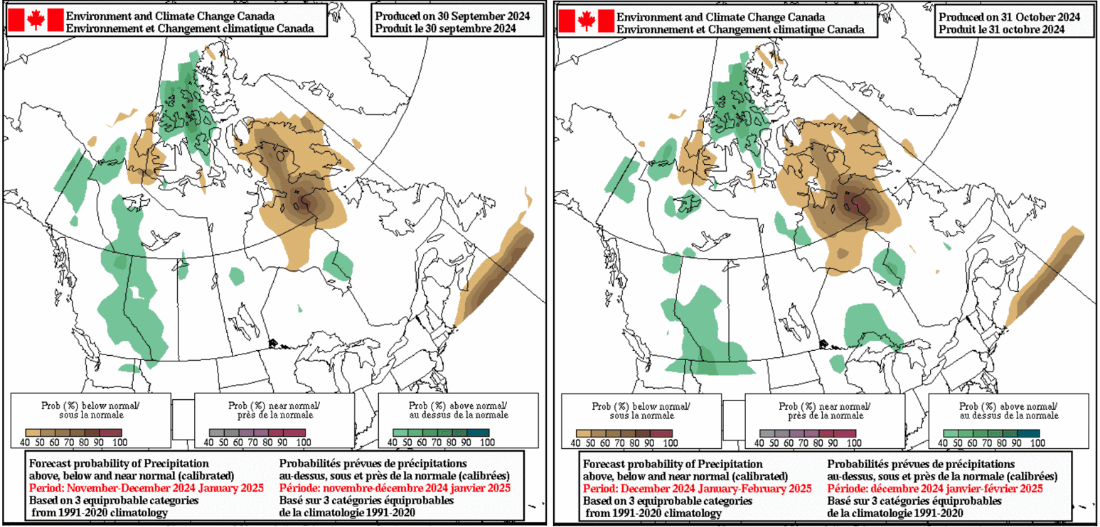
The updated Environment Canada seasonal forecasts against their month-old counterparts are shown below, the older forecasts run from November-January and the newer forecasts run from December to February. It is similar to NOAAs outlook and a we might have expected the southwest of Canada is best positioned with cooler than average temperatures forecasted, and the slightly wetter conditions forecasted are mainly confined to the Canadian Rockies.
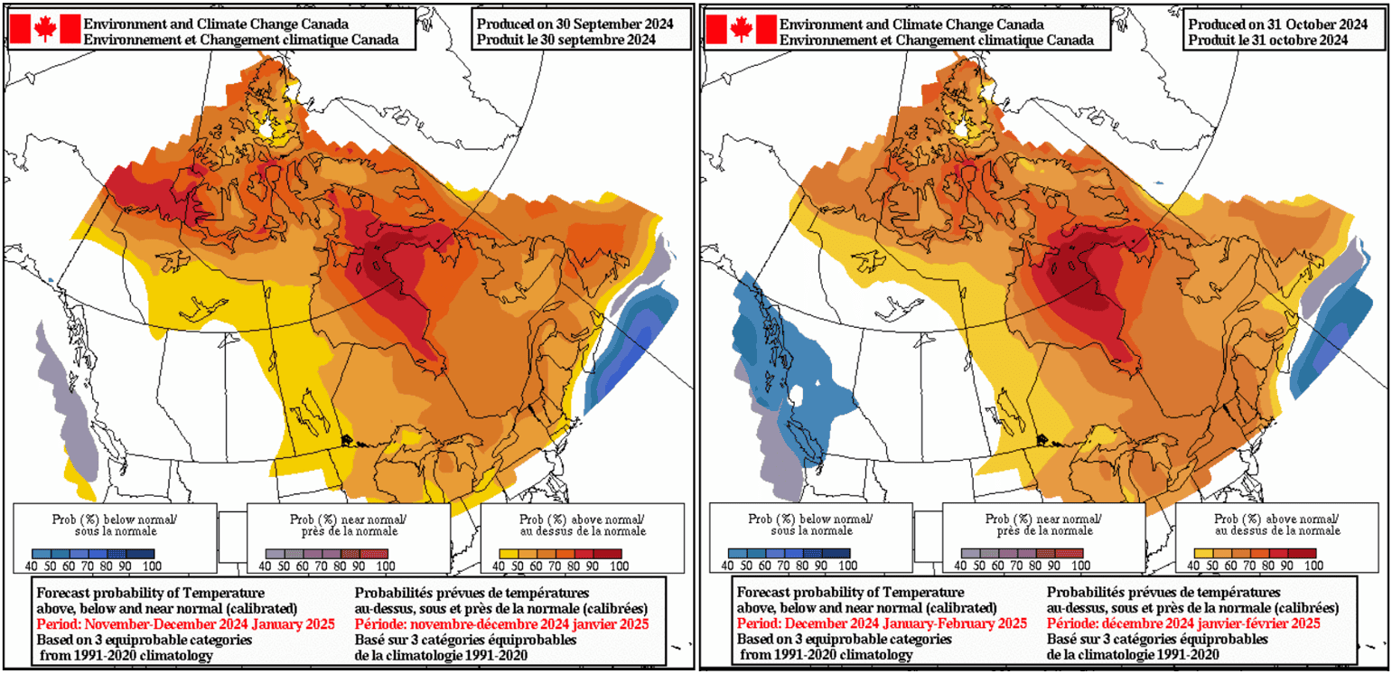
The Environment Canada seasonal temperature forecast products for, Nov-Jan from last month (left) and Dec-Feb from this month (right). Source: Environment Canada.


The Environment Canada seasonal precipitation forecast products for, Nov-Jan from last month (left) and Dec-Feb from this month (right). Source: Environment Canada.

So, after all those comparisons where does it leave us? The most likely scenario at this point is a weak La Niña event peaking during the winter season. That should mean cooler, below-average temperatures and average-to-wetter conditions around the northwestern United States and southwestern Canada. Neutral conditions are expected through the more central latitudes of the United States, while further south drier and warmer conditions overall are more likely.

The result could mean above average snowfalls and colder temps for ski resorts in Oregon, Washington, Montana, Idaho and Wyoming and north of the border in British Columbia. Columbia. Of course, neutral conditions free of major climate drivers elsewhere mean everywhere has a good chance to see some decent storms and an overall good season.

I’ll have my next update in around a month’s time and stay tuned for my weekly North American forecasts, due to start in mid-December.
GeoLines(4000×2000)
Posted on Google Google
nicky sullivan profile picture
nicky sullivan
Google star 1Google star 2Google star 3Google star 4Google star 5Trustindex verifies that the original source of the review is Google.
Lizzie was so helpful, gave us some options and advice to help us pinpoint where we wanted to go. And once we had booked provided some really helpful travel advice and answering questions we had. Easy to deal with, everything was smooth and we had a great time.
Posted on Google Google
Shelly Drewitz profile picture
Shelly Drewitz
Google star 1Google star 2Google star 3Google star 4Google star 5Trustindex verifies that the original source of the review is Google.
Calum was awesome at helping us every step of the way with our trip. We got a great deal on the accommodation and ski lift, and we will definitely come back to Mountainwatch next time based on his excellent service.
Posted on Google Google
Mark K Grant profile picture
Mark K Grant
Google star 1Google star 2Google star 3Google star 4Google star 5Trustindex verifies that the original source of the review is Google.
I booked my Japan ski holiday through Mountainwatch. Very professional and when we arrived in Japan all was laid out for us. The accommodation was even nicer than expected. KIrsty was very good to work with and made things very easy!!!! will book again next season.
Posted on Google Google
Jess profile picture
Jess
Google star 1Google star 2Google star 3Google star 4Google star 5Trustindex verifies that the original source of the review is Google.
Great experience booking through this company, our contact Anna was brilliant, and organised a fantastic ski trip for us. The travel was all clearly laid out, the accommodation was lovely, the ski field was fantastic, great range of local dining options and bars.
Posted on Google Google
Brett A profile picture
Brett A
Google star 1Google star 2Google star 3Google star 4Google star 5Trustindex verifies that the original source of the review is Google.
Mountain Watch are great, well organised and excellent advice on locations and accommodation. Highly recommended!
Posted on Google Google
darren martin profile picture
darren martin
Google star 1Google star 2Google star 3Google star 4Google star 5Trustindex verifies that the original source of the review is Google.
Thanks Kirsty for helping arrange our family trip to Myoko for Xmas 2025, we had an amazing time
Posted on Google Google
Jan Kelly profile picture
Jan Kelly
Google star 1Google star 2Google star 3Google star 4Google star 5Trustindex verifies that the original source of the review is Google.
Thanks Kirsty, once again your arrangements for us in Japan worked very well. We’ll have no hesitation about touching base with you before we make another booking….. not sure if we’ll be organised by June, but we’ll see. Have a great season yourself and keep up the good work at MountainWatch. Regards Jan and Tom
Posted on Google Google
Samantha Farr profile picture
Samantha Farr
Google star 1Google star 2Google star 3Google star 4Google star 5Trustindex verifies that the original source of the review is Google.
Our trip to Hakuba and Tokyo was so smooth and easy thanks to the help of Justine. Hotel was great and in a perfect location and it was very smooth having all our extras like lessons and rentals booked and sorted before we arrived. Would 100% book through Mountainwatch Travel again!
Posted on Google Google
John Durham profile picture
John Durham
Google star 1Google star 2Google star 3Google star 4Google star 5Trustindex verifies that the original source of the review is Google.
This is the second year that Kristy has organized travel arrangements for a skiing holiday to Furano in Japan, for us. It is the second time that those arrangements have been fulfilled seamlessly. No hassles, as planned and on time. Perfect, and will use Mountainwatchj Travel again. John Durham
Posted on Google Google
Simone B profile picture
Simone B
Google star 1Google star 2Google star 3Google star 4Google star 5Trustindex verifies that the original source of the review is Google.
We booked through Anna O’Malley for our stay in Nozawa onsen Village in Japan. Seamless service, prompt, and pricing reasonable. The Shimataya View Hotel, was a lovely stay. Room size was large, great views, and Amazing service from Staff. Momoi and Eloisa couldn’t help enough- from dinner reservations to organising luggage to Tokyo. Property is older, though clean, well maintained. 10 min walk to slopes, 5 min walk to village centre. I recommend Mountain Watch, and this property. Photos are the view from our room.
Verified by Trustindex
Trustindex verified badge is the Universal Symbol of Trust. Only the greatest companies can get the verified badge who has a review score above 4.5, based on customer reviews over the past 12 months. Read more
contact-us

HAVE ANY QUESTIONS? Speak to one of our ski travel specialists today!

GET A QUOTE