Grasshopper’s New Zealand 2024 Snow Season Outlook – Colder Winter with Small But Frequent Top-Ups for South Island Resorts
Mountainwatch | The Grasshopper
As we reach the tail-end of autumn, any remaining El Niño effects fade away. Wintry air masses have already started their annual pilgrimage across New Zealand, with the potential for a more promising ski season than seen in recent years for many South Island fields.
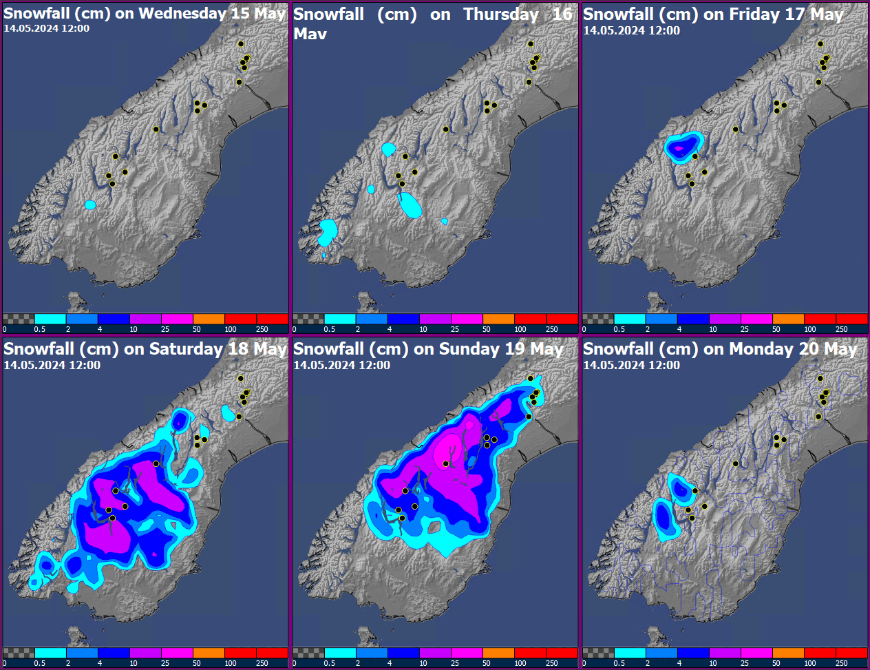
Another cold front will move across the lower South Island early Saturday 18th, accompanied by a southerly cold pool. This front is likely to become slow-moving across central or southern South Island through the remainder of the weekend, but there is considerable uncertainty on where this stalling will take place.
Currently, the Remarkables are picked to see a decent shot for snow during Saturday, with that slow-moving front shifting slightly northwards during Sunday closer to Ohau and potentially Mt Hutt, before easing away Monday.
A cold start to winter
Temperatures plummeted during the first half of May and will remain below average through the remainder of the month with a notable cold snap likely towards the end of the month. Ski fields across the South Island should see ample opportunities for snowmaking and building up the bases in the lead-up to the winter season.
Natural snow is also likely to contribute for western and southern ski fields with short but more frequent bouts of snow in the cold south-westerly flow. In contrast, Ruapehu fields will trend cooler but slightly drier through the remainder of May.
Looking further ahead, while El Nino has largely eased, it’s atmospheric effects –enhanced/more frequent west-to-southwest winds – are still likely over the next month or two, delivering more frequent fronts to the southwest of the South Island, as we’ve been seeing recently.
The Indian Ocean Dipole (IOD), is another influential climate driver which is forecast to tip positive, helping maintain a strong/active W-SW flow, increased the chance of fast-moving fronts bringing short bursts of snow/cold air across the South Island, quite similar to El Nino. This will ease towards the end of winter.
Southern Ocean’s Influence
The start of winter should be much more seasonable as the Southern Ocean becomes the largest influence on New Zealand weather systems. Sea surface temperatures south of the country are trending 2-3oC below normal, so any weather system (and there will be quite a few) passing over will maintain their chill-factor as they travel across the South Island.
Overall, this winter looks likely to play out quite differently compared to previous years (chilly!), which saw four of the five warmest winters on record. While seasonal climate models are still picking warmer-than-normal NZ winter temperatures, I reckon it is much more likely that New Zealand sees a comparatively cooler winter season ahead.
Why? Well, the climate models have consistently been over-forecasting the temperature warmth across New Zealand for the past two months, and the most likely reason is that cold anomaly in the sea surface temperature south of the country. At 2-3C below average it is quite pronounced and any weather system moving northwards from the Southern Ocean and across NZ is much more likely to maintain its cold air mass. Add to this the increased frequency of these southerly fronts, then we’re expecting a bit chillier winter that overall, will feel a bit colder compared to previous five years.
Quick snow-bearing cold fronts to favour the South Island
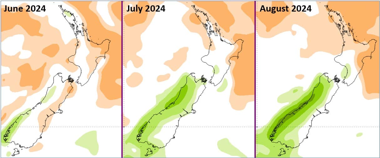
Near-average snowfall is expected during June across most South Island ski fields, with the bulk arriving in short but sharp bursts as quick-moving cold fronts whip up the country, followed by a short period of blue skies and lighter winds. The exception will be more sheltered eastern fields (Hammer Springs, Lyford, Fox Peak, Cheeseman), where snow amounts are more likely to trend close to, or slightly below, normal.
Further north, Ruapehu fields will see diminishing returns in this south-westerly flow. While semi-regular top-ups are likely with passing fronts, these may be offset by more frequent and longer-lasting high-pressure systems. But fear not, this only increases the odds of a string of blue bird days once the snowpack has been established.
As we head into July and August, at this stage it looks like the South Island ski fields remain firmly in the crosshairs. The cold south-westerly flow should become more vigorous, with the Southern Ocean throwing more frequent fronts and snow top-ups to southern and western South Island fields, with good confidence of slightly above average snowfall there.
Ruapehu and the Eastern South Island fields may miss out on many of these events, with the ski season trending slightly drier than normal. However, cooler-than-normal temperatures should assist in their snowmaking efforts.
Wrap-up
With most of the snowfall arriving from the southwest, significant snow events across all New Zealand ski fields are less likely this year. However, the odd big snow dump out of the southeast remains possible and will typically produce good snow amounts if they do occur. Likewise, the risk for a warm northerly weather system triggering a significant melting event is also reduced, while the chance of seeing late season cold snaps is much higher than in previous years. This is particularly true across the South Island, and there is potential for the ski season to extend a bit further into the spring season.
As in any season, it’s often about timing, and the best way to time it right is to keep a handle on weather forecasts, which you can do right here on Mountainwatch with top-of-the-line model data, and twice weekly New Zealand forecasts by yours truly starting early June.
That’s it from me folks. If you’ve got a different theory on what’s going to happen this winter, or just want to provide feedback, then please hit me up on Facebook and hit the follow button while you’re at it.
The Grasshopper


