2024-2025 North American Snow Season Outlook
What La Niña Could Mean for Some of Our Favourite Resorts
Mountainwatch | The Grasshopper
We’ve recently seen a few early snowfalls in some parts of North America, so it’s come to that time again where we gaze across the North Pacific to see what the upcoming season may deliver. If you’ve already read the Japan season outlook, you’ll know it looks likely we are headed towards a La Nina developing over the last couple of months of the year.
What does that mean for North America, I hear you ask? Stay tuned for answers to that and all your other North American meteorological questions below.
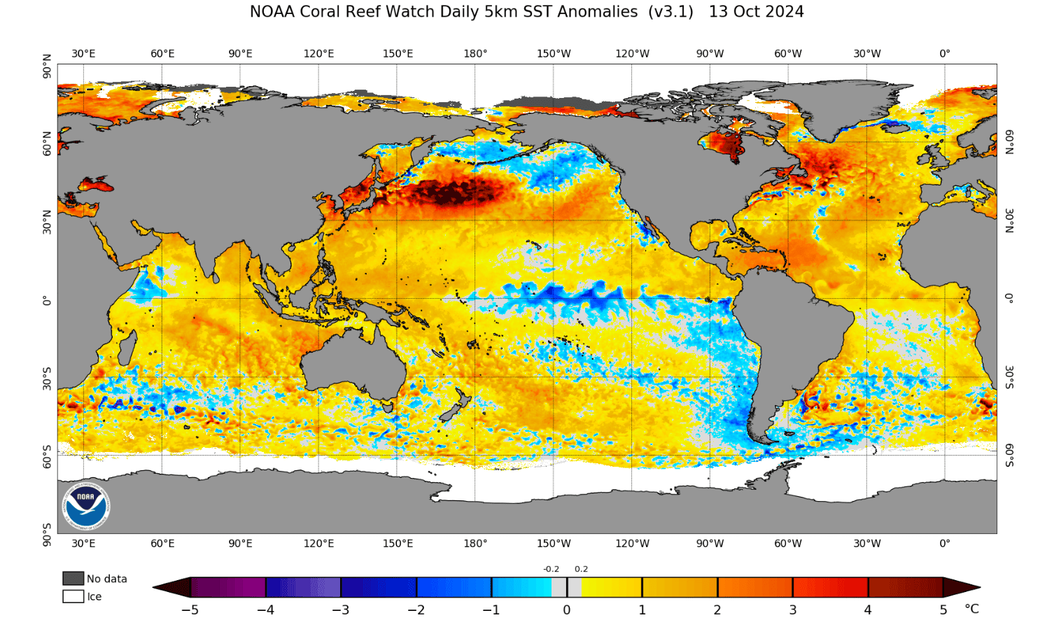
Starting off again with the El Niño–Southern Oscillation (ENSO), the biggest player in the climate driver scene and the main focus of this update. Right now, conditions in the equatorial Pacific are still within the neutral range but are predicted to dip into the La Nina threshold as we head towards the Northern Hemisphere winter.
NOAA (National Oceanic and Atmospheric Administration) is putting the number at 60% chance of a La Niña emerging from now to before the end of November and persisting through winter until early next year. The SST (sea surface temps) picture below shows us the current state with some cool temperatures through the central-eastern equatorial Pacific making an appearance and also warmer than normal waters in the western Pacific, a good sign that we are indeed heading into a La Niña.
ENSO effects different parts of the world in different ways and even different parts of North America specifically as well. In simple terms it does this through variations in pressure in the northern Pacific promoting changes in the typical storm track, leading to more storms hitting these areas. The changes in the storm track are also related to changes in position of Jet streams which can bring both cold temperatures and plenty of moisture for those big winter storms.
La Niña winters have been historically deep in some parts of North America but because snowfall is regionally specific it tends to bring deeper snowfall seasons to areas like the Canadian Rockies, the Pacific Northwest and the Northern Rockies in the United States. However, it can bring drier than average conditions in further southern areas of the American Rockies and California’s Sierra Nevada for a general guide. This doesn’t mean a good season isn’t possible in these areas; it just changes the likelihood. Also, the fact a potential La Niña this year may not be very strong could result in neutral conditions in some of these mountains.
The seasonal forecast for MSLP (mean sea level pressure) again shows signs of a nearing La Niña: higher pressures through the Central-Eastern Pacific, lower pressures through the Maritime Continent and higher pressures through the Northern Atlantic. The anomalously higher pressures in the North Atlantic is one of La Niña’s ways of talking to the North Americas, altering the regular low-pressure circulations in this area (known as the Aleutian Low) which is what helps to shift the storm track as mentioned above.
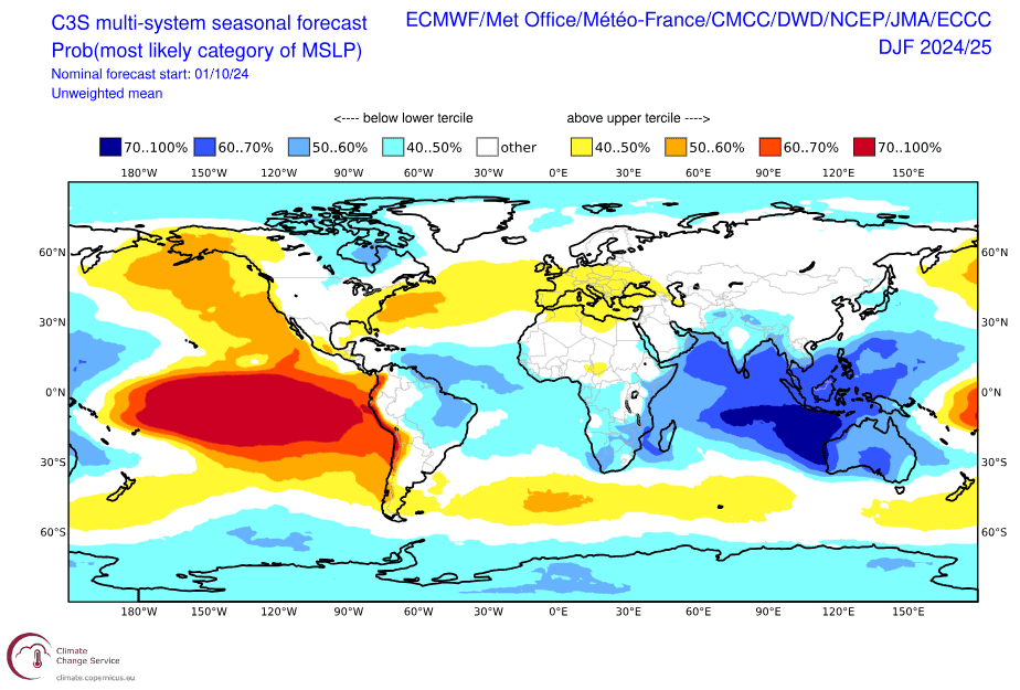
One thing to note is that the forecasted temperature anomalies in the Pacific which are used to determine whether ENSO is positive/neutral/negative (El Nino/Neutral/La Niña) are indicating a weak La Niña this winter, which may mean we see teasers instead of the entire show.
The La Niña picture is roughly what we see from the NOAA and Environment Canada precipitation and temperature outlooks for this winter (December through February). Wetter and slightly colder in the Canadian Rockies PNW, wetter in areas of the Northeast and neutral chances becoming drier and warmer as you head further south in the continent.
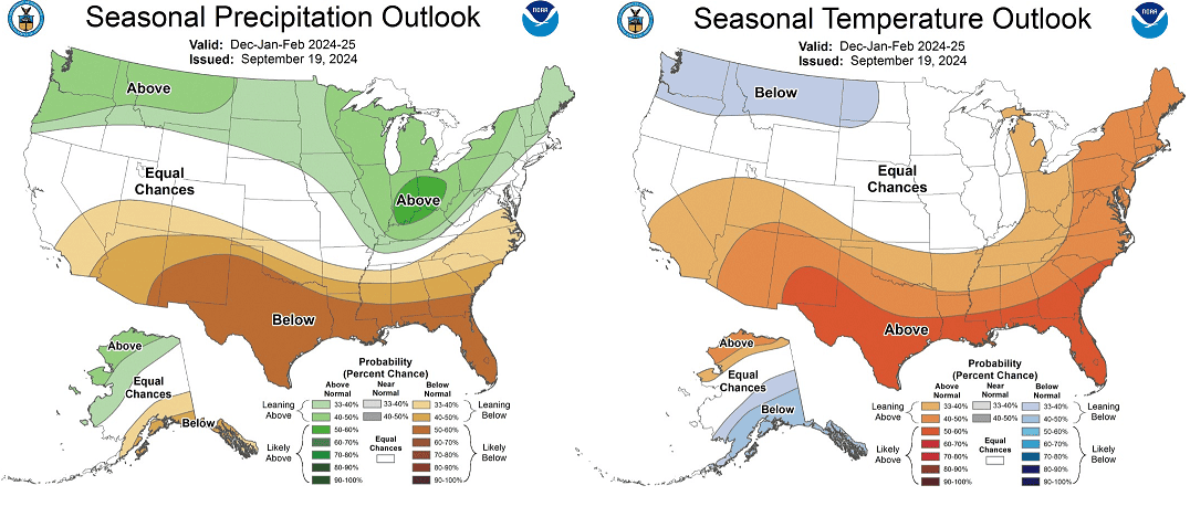
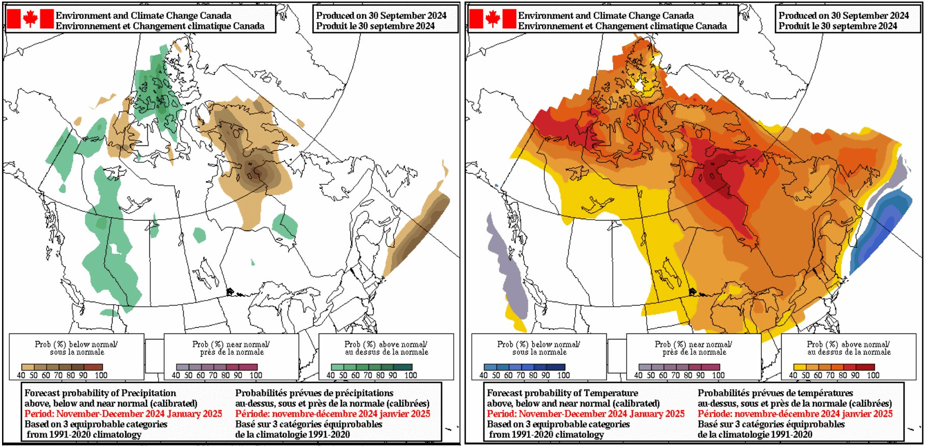
It is worth remembering that seasonal forecasts give us hints about where we may find the deepest pockets of snow this season but due to the weather’s chaotic nature seasonal forecasts are not an exact science. What they can do though is highlight where to start looking and as it starts to cool down and it is looking optimistic for many of our favourite resorts in Canada and the USA.
Stay tuned for my monthly updates as we head closer into winter with seasonal forecasts becoming more accurate in the lead up.


