2023-2024 North American Snow Season Outlook- What We May See in an El Niño Year - MountainWatch Travel
CALL NOW MESSENGER
Skier exploring the mountains at Aspen Snowmass

2023-2024 North American Snow Season Outlook- What We May See in an El Niño Year
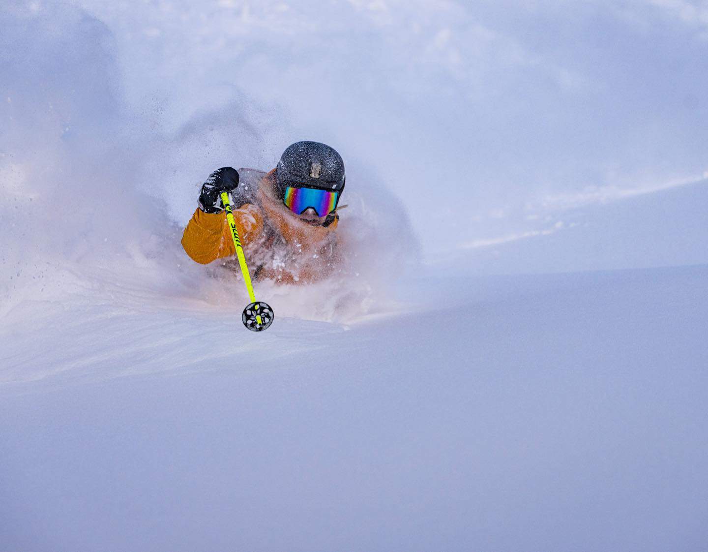
Aimee Engerbretson during a deep day at Palisades Tahoe last December. Last season was a record year for the Sierras and in an El Niño year above average snow totals are likely again this season Photo: Jeff Engerbretson

Mountainwatch | The Grasshopper

North America 2023-2024 snow season is on the map. The first series of legitimate snow storms rolled through last week, bringing freezing temperatures and deep powder to many resorts out west. From the Cascades in the northwest, to the Rockies of Alberta down to Utah and Colorado, a solid 20-50cm+ has been dumped, turning everything wonderfully white and providing a timely boost for resorts who are looking to open their gates within the next several weeks – for some in the next few days.

Snowmass, Colorado, appears to have received the biggest walloping, with a storm total of 81cm. That’s about the standing height of a Wallaby! (the Bennett’s variety, not the Aussie rugby player type). It’s enough to get one frothing, which inevitably leads one to ask the question: what’s the snow going to do this season?
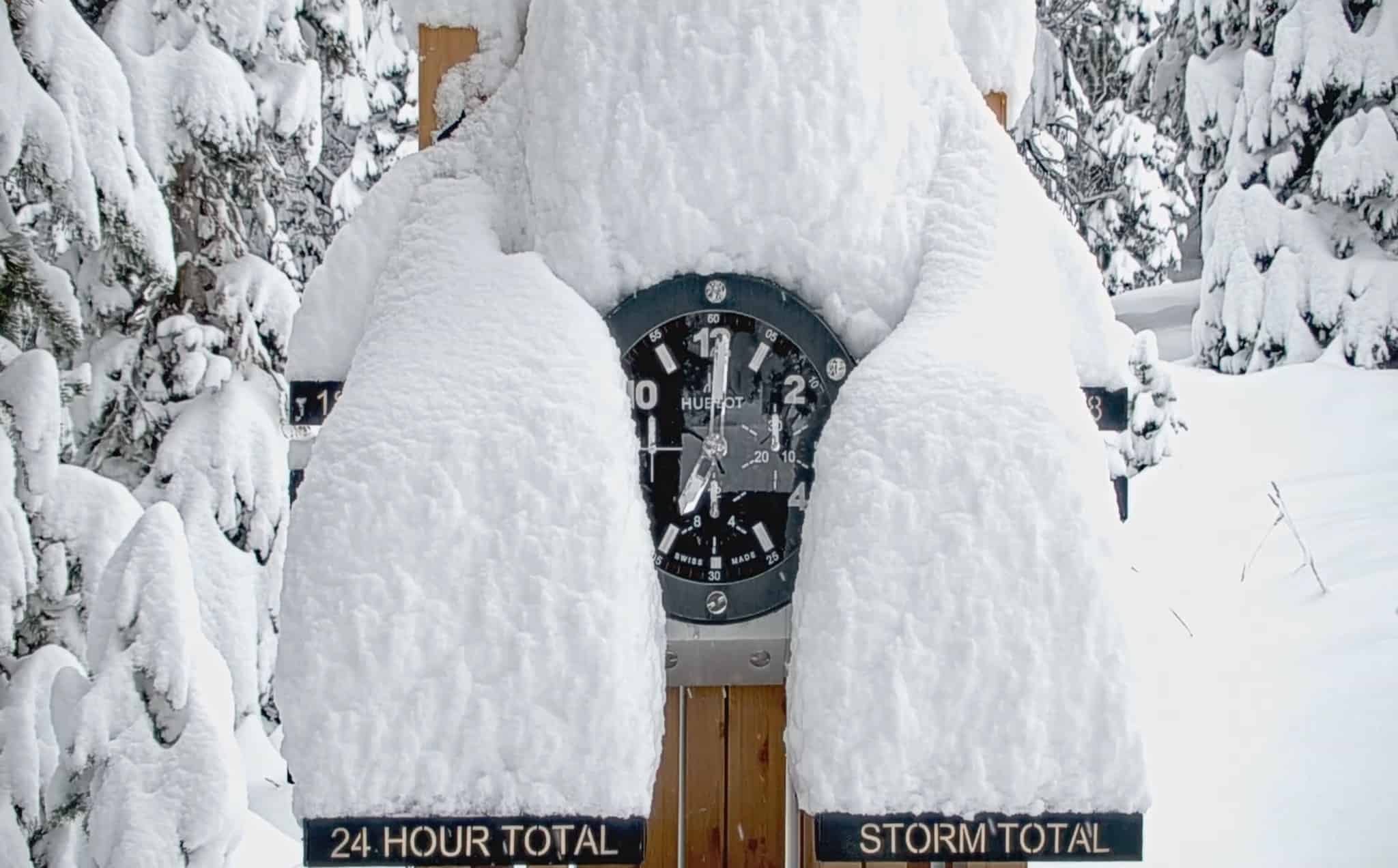
The snow stake cam in Aspen Snowmass after last week’s storm dropped 81cms.

To answer that question, we need to look at is what’s happening far, far away – across the tropical region of the Pacific Ocean. Here, we find the see-sawing of sea surface temperatures (SST), winds and convection on a monthly to yearly timescale – a pattern called the El Niño Southern Oscillation, aka ENSO, which most of you savvy readers have heard about by now.

Right now, the ENSO is in full blown El Niño mode, with warmer than average SST across the tropical Pacific. A particular region of interest in the middle, called the Niño 3.4 region, is currently 1.6°C above average, which falls within the “strong” El Niño category. Continued warming is expected over the next couple of months, and we could see this El Niño reaching the haughty heights of a “very strong” event (Niño 3.4 ≥ 2°C), before starting to cool off later in the season.

These strength categories are fairly arbitrary and unofficial, but usually, the stronger the El Niño, the more likely it is that we’ll see its mitts all over our maps. However, with warm SST prevailing almost everywhere else across the globe, this El Niño may not stand out as it once would have.
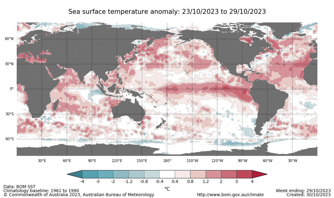
Sea surface temperature (SST) anomalies from the past week showing El Niño warmth across the tropical Pacific Ocean, as well as a positive Indian Ocean Dipole (IOD). SST are also predominantly warm elsewhere throughout the globe. Source: The BOM

August was the warmest out of any month for global SST since records began way back in 1854, while September was the second warmest. El Niño tends to make earth a warmer place, so we could still see these records surpassed even further in the coming months. It’ll be interesting to see if this has a tempering effect on atmospheric responses to this El Niño event. The atmosphere has already kicked into El Niño gear, but it isn’t exactly topping the charts at this point in time.

What effect does El Niño have on North American snowfall? Well, more often than not we see more snow than average in the Sierras, and southern Rockies of Utah, Colorado, Arizona and New Mexico. The Rockies further north, as well as the Cascades, often see less than average.
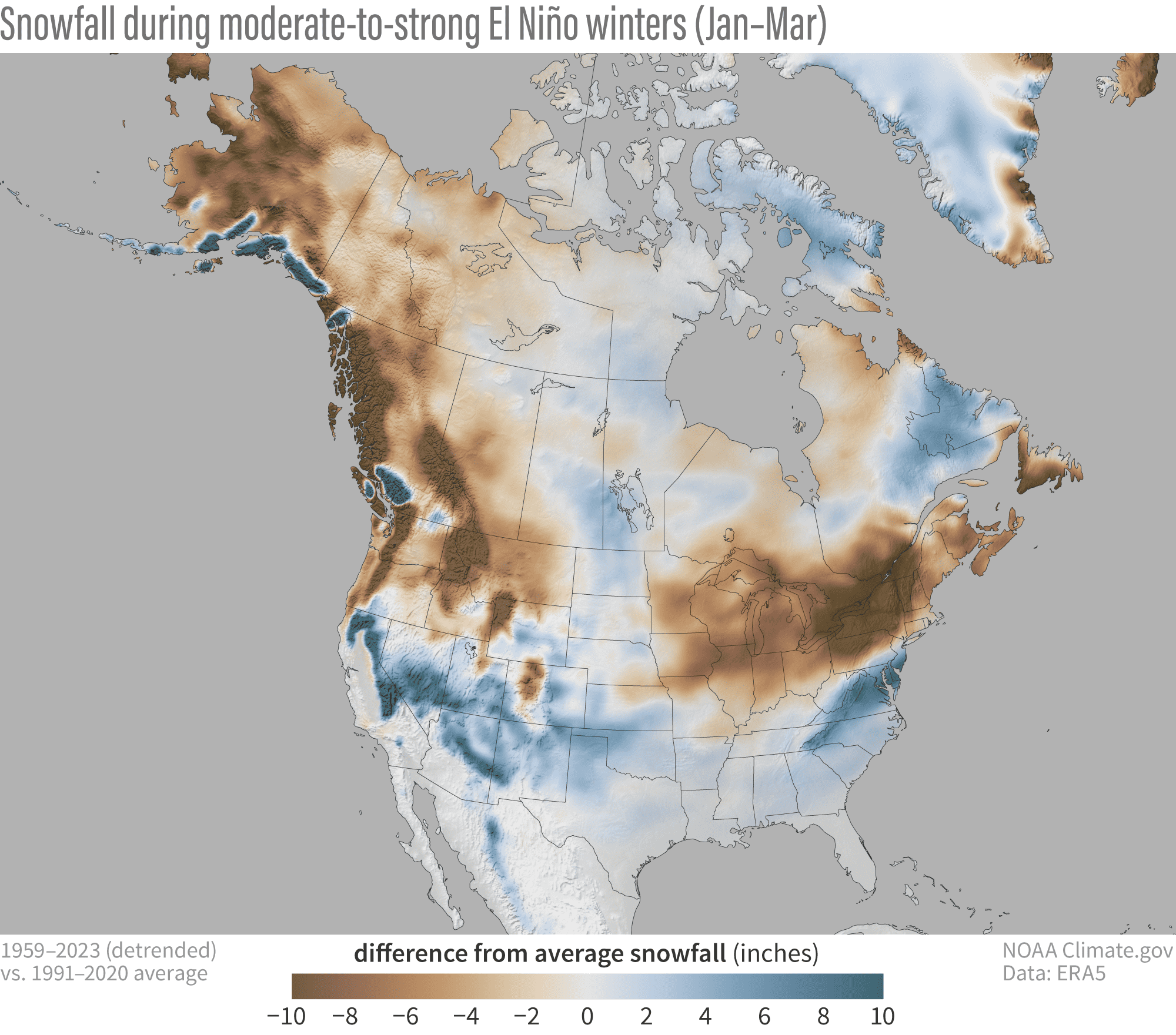
Snowfall anomalies during moderate-to-strong El Niño winters (Jan-Mar) after the long-term trend has been removed. El Niño generally favours the south over the north for snowfall, an effect that becomes even more pronounced during moderate-to-strong events. Source: Michelle L’Heureux and the ENSO blog team at the NOAA Climate Prediction Centre

However, El Niño’s influence is a little more nuanced than it appears at first glance. To understand some of these intricacies, it helps to first understand how El Niño modifies the atmosphere to make the south snowier than the north.

During El Niño events, the Subtropical Jetstream tends to shifts southwards over the Pacific Ocean while strengthening eastwards towards North America. This has the effect of steering storms out of the north Pacific and across the southern tier of North America, resulting in more snow there. This southern storm track is neatly illustrated in the image below.
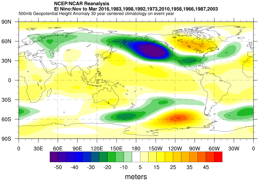
Composite 500mb geopotential height anomalies from previous El Niño snow seasons (Nov-Mar). Cool hues show areas of increased storm activity, while warm hues indicate areas of supressed activity. An enhanced storm track can be clearly seen emanating out of the north Pacific and over the southern tier of North America, while the northern U.S. and Canada are generally calmer. Source: NCEP/NCAR reanalysis data from NOAA’s Physical Sciences Laboratory.

However, if you squint at the El Niño snowfall image, you’ll notice that those mountains exposed to the east tend to fare better than their counterparts immediately to their west. This is because we tend to see easterly wind anomalies (or rather weaker westerlies) on the northern side of this heightened storm activity across the south. It’s a kind of reversal, or weakening, of the usual rain shadow effect, which normally sees more precipitation falling in mountains exposed to the west, while those areas to the east are much drier.

For example, the Front Range in Colorado may fare better than the Park and Sawatch Ranges just to the west, or that the Wasatch Range in Utah looks a little underdone compared to elsewhere in the state. It’s the same for the Sierras; the eastern slopes may fare better than the western slopes where warmer temperatures along the west coast can also affect snow levels. The same could be said for the Cascades and elsewhere in the Rockies.

The only glitch in this picture is an area of higher than average snowfall over the southern Coastal Mountains of Canada. The only explanation I can come up with to answer this oddity is that here the mountains are high enough, and lie perpendicular enough to a more southerly tilted flow so as to pick up some of the plentiful precipitation which lies just off the coast during El Niño.
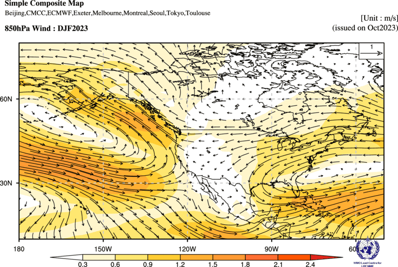
Model wind anomalies at 850hPa (roughly 1500m altitude) for the upcoming winter (Dec-Feb). Easterly wind anomalies are typical over much of the US and Canada during El Niño seasons, especially over the northern U.S. and Canada, often leaving mountains exposed to the east relatively snowier than those to the west. Source: WMO Lead Centre for Long-Range Forecast Multi-Model Ensemble

As you might expect, the bulk of climate models as well as the winter outlook produced by NOAA’s Climate Prediction Centre have El Niño’s greasy finger prints all over them. The odds favour the south having a bumper season. However, warm temperatures could affect resorts in the Sierras, where snow levels and snow quality could be more of an issue than usual.

The northern U.S. and Canada are most likely to see below-average snowfall, but when we’re talking average annual snowfalls of somewhere in the ball park of 5-12 metres, a little less may not go a miss (yes, I did get very side-tracked scrolling through the statistics of dozens of resorts while trying to image such quantities of powder).
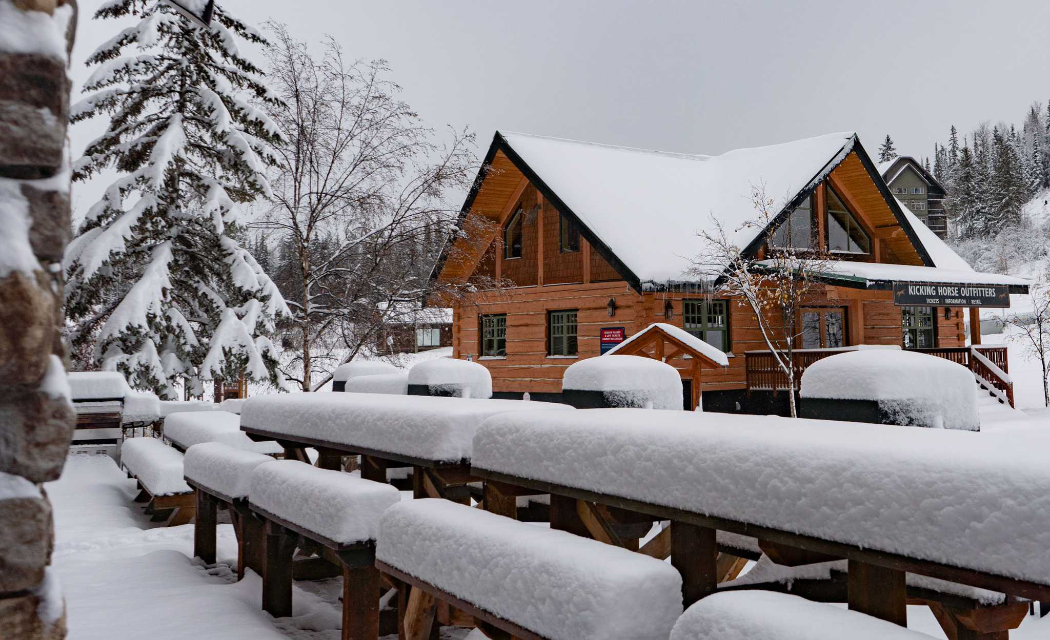
Early snow in Kicking Horse, BC last week. While an El Nino may mean below average snow totals for Canadian resorts, Kicking Horse has a season average of 6.5-7.5 metres, so it should still see a fair few pow days. Photo: Kicking Horse Mountain Resort

Although warmer temperatures could also be an issue for low elevations of the Cascades and Coast Mountains, the interior regions are less affected by rain, as it remains cold there, and whatever snow falls tends to stick around.

Well, that’s about it from me for now guys and gals. Remember, the discussion above is dealing with averages over the length of a season. But we all know it’s often more about timing, and the best way to do that is to stay in tune with the weather, which you can do right here on Mountainwatch, where I’ll be issuing weekly forecasts for North America and Japan starting in December. Until then…

Grasshopper
GeoLines(4000×2000)
Posted on Google Google
nicky sullivan profile picture
nicky sullivan
Google star 1Google star 2Google star 3Google star 4Google star 5Trustindex verifies that the original source of the review is Google.
Lizzie was so helpful, gave us some options and advice to help us pinpoint where we wanted to go. And once we had booked provided some really helpful travel advice and answering questions we had. Easy to deal with, everything was smooth and we had a great time.
Posted on Google Google
Shelly Drewitz profile picture
Shelly Drewitz
Google star 1Google star 2Google star 3Google star 4Google star 5Trustindex verifies that the original source of the review is Google.
Calum was awesome at helping us every step of the way with our trip. We got a great deal on the accommodation and ski lift, and we will definitely come back to Mountainwatch next time based on his excellent service.
Posted on Google Google
Mark K Grant profile picture
Mark K Grant
Google star 1Google star 2Google star 3Google star 4Google star 5Trustindex verifies that the original source of the review is Google.
I booked my Japan ski holiday through Mountainwatch. Very professional and when we arrived in Japan all was laid out for us. The accommodation was even nicer than expected. KIrsty was very good to work with and made things very easy!!!! will book again next season.
Posted on Google Google
Jess profile picture
Jess
Google star 1Google star 2Google star 3Google star 4Google star 5Trustindex verifies that the original source of the review is Google.
Great experience booking through this company, our contact Anna was brilliant, and organised a fantastic ski trip for us. The travel was all clearly laid out, the accommodation was lovely, the ski field was fantastic, great range of local dining options and bars.
Posted on Google Google
Brett A profile picture
Brett A
Google star 1Google star 2Google star 3Google star 4Google star 5Trustindex verifies that the original source of the review is Google.
Mountain Watch are great, well organised and excellent advice on locations and accommodation. Highly recommended!
Posted on Google Google
darren martin profile picture
darren martin
Google star 1Google star 2Google star 3Google star 4Google star 5Trustindex verifies that the original source of the review is Google.
Thanks Kirsty for helping arrange our family trip to Myoko for Xmas 2025, we had an amazing time
Posted on Google Google
Jan Kelly profile picture
Jan Kelly
Google star 1Google star 2Google star 3Google star 4Google star 5Trustindex verifies that the original source of the review is Google.
Thanks Kirsty, once again your arrangements for us in Japan worked very well. We’ll have no hesitation about touching base with you before we make another booking….. not sure if we’ll be organised by June, but we’ll see. Have a great season yourself and keep up the good work at MountainWatch. Regards Jan and Tom
Posted on Google Google
Samantha Farr profile picture
Samantha Farr
Google star 1Google star 2Google star 3Google star 4Google star 5Trustindex verifies that the original source of the review is Google.
Our trip to Hakuba and Tokyo was so smooth and easy thanks to the help of Justine. Hotel was great and in a perfect location and it was very smooth having all our extras like lessons and rentals booked and sorted before we arrived. Would 100% book through Mountainwatch Travel again!
Posted on Google Google
John Durham profile picture
John Durham
Google star 1Google star 2Google star 3Google star 4Google star 5Trustindex verifies that the original source of the review is Google.
This is the second year that Kristy has organized travel arrangements for a skiing holiday to Furano in Japan, for us. It is the second time that those arrangements have been fulfilled seamlessly. No hassles, as planned and on time. Perfect, and will use Mountainwatchj Travel again. John Durham
Posted on Google Google
Simone B profile picture
Simone B
Google star 1Google star 2Google star 3Google star 4Google star 5Trustindex verifies that the original source of the review is Google.
We booked through Anna O’Malley for our stay in Nozawa onsen Village in Japan. Seamless service, prompt, and pricing reasonable. The Shimataya View Hotel, was a lovely stay. Room size was large, great views, and Amazing service from Staff. Momoi and Eloisa couldn’t help enough- from dinner reservations to organising luggage to Tokyo. Property is older, though clean, well maintained. 10 min walk to slopes, 5 min walk to village centre. I recommend Mountain Watch, and this property. Photos are the view from our room.
Verified by Trustindex
Trustindex verified badge is the Universal Symbol of Trust. Only the greatest companies can get the verified badge who has a review score above 4.5, based on customer reviews over the past 12 months. Read more
contact-us

HAVE ANY QUESTIONS? Speak to one of our ski travel specialists today!

GET A QUOTE